

Joseph Wampler
In 1820, surveyor Joseph Wampler was making his way through the area that would, in 1895, be known as Rattlesnake Corners, or simply “The Corners.” Today, we know the intersection as Central and Holland-Sylvania. The black dot in the 1820 capture above represents the intersection.
Wampler’s survey provides one of the earliest documented glimpses of what the area around the Corners looked like in 1820, before major European development altered the natural setting that had existed there for thousands of years.
The intersection of Central and Holland-Sylvania is the crossroads in the center of four Sylvania Township sections. These sections are 22, 23, 26, and 27. Each of these sections is one-mile square.

In each of the four sections Wampler recorded “Plain land.” By plain land, he meant prairie, meadow, or other open landscape.

Near what is now the intersection of University Parks Trail and McCord Road, Wampler described the area as “locusty,” with oak, aspen, willow, and hazel. The symbols on his survey indicate this area was wet or swampy ground.

His observations confirm that the area was not simply a continuous expanse of dense forest or plains. Black and white oak trees grew across relatively open, better-drained ground, with prairie and meadow-like areas interspersed among wetter areas where willow, aspen, hazel, and other vegetation grew more densely.

The area around the Corners was a patchwork of open ground, oak-covered areas, streams, springs, marshes, and swamp. The landscape supported abundant wildlife, including deer, gray wolves, black bears, wildcats, foxes, turkeys, ducks, and geese. Narrow, winding trails crisscrossed the landscape, following routes long used by Indigenous people and wildlife.
Indigenous Dispossession
Wampler’s survey was part of a much larger transformation already underway.
Through a succession of treaties, Indigenous nations, including the Wyandot, Ottawa, Potawatomi, and Ojibwe, had been dispossessed of vast areas of northwestern Ohio by the United States, even though many Native people still remained on and used these lands when Wampler surveyed them in 1820.
Federal surveyors such as Wampler were dividing these newly acquired lands into regular townships, sections, and quarter-sections, creating the system through which they could be sold and settled by others.
The Indian Removal Act of 1830 and the forced removals that followed would extend and intensify this process, driving Native communities from much of the territory claimed by the United States.
Within a few years, the survey lines Wampler helped establish would become the framework for private ownership, and the landscape he recorded would begin to change with increasing speed.
Among those who would seize the opportunity was a young and wealthy landowner from Geneseo, New York.
1835: William Wolcott Wadsworth
William Wolcott Wadsworth belonged to one of the most prominent landowning families in western New York. Like many men of his class and means, he viewed the rapidly developing lands of the Midwest as an opportunity for investment. Rather than establishing a permanent residence or operating farms himself, he acquired acreage with the expectation that its value would rise as settlement advanced and roads, markets, and communities developed around it.
His older brother, James Samuel Wadsworth, also acquired substantial acreage in northwestern Ohio. As absentee landowners, their Ohio properties were managed from their land office located at 1 Main Street in Geneseo, New York.
In spring of 1835, the Wadsworth family sent Benjamin Joy, from Genesee County, to northwestern Ohio. Joy quickly established himself in Lucas County as the Wadsworths’ local agent, overseeing their interests in Ohio and southeastern Michigan. An April 18, 1835, letter from William Wadsworth to Joy included “Instructions for purchasing,” providing direction for acquiring additional land.
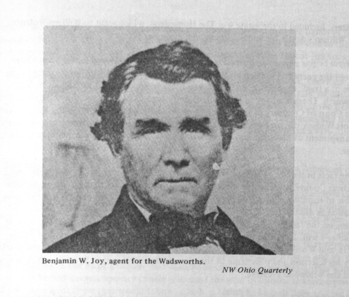
With the help of Joy, William Wadsworth began acquiring his Ohio lands in October 1835, purchasing them through the federal land office at Monroe, Michigan. Among his earliest acquisitions was the south half of Section 22, containing 320 acres.
The south half of Section 22 is today the area bounded by Central Avenue, Holland-Sylvania Road, McCord Road, and University Parks Trail (which closely parallels Blossman Road).
On October 1, 1835, the United States issued Wadsworth a patent for the tract, recording that full payment had been made under the provisions of the Act of April 24, 1820. The patent identifies Wadsworth as a resident of Livingston County, New York, and describes the land as lying within the federal district offered for sale at Monroe, Michigan Territory.

The purchase was a cash entry under the federal land system established by the Land Act of April 24, 1820. The act set the minimum price at $1.25 per acre and required full payment for cash purchases. At that rate, the 320-acre tract cost Wadsworth $400.
Bureau of Land Management General Land Office patent records show that William Wadsworth acquired additional lands directly from the United States between 1835 and 1837, with the majority of his purchases occurring in 1835. In addition to the south half of section 22 and most of section 26, he also acquired sections 23, 27, and 28 in full, along with many portions of adjoining sections, eventually totaling more than 30,000 acres. At $1.25 per acre, that’s a total cost of $37.500.
1837: Fountain Hill

By 1837, Wadsworth’s holdings in the area extended across many sections. Within those holdings was a newly established agricultural operation he called “Fountain Hill” in the northwest corner of Section 23, currently the southeast corner of Sylvania and Holland-Sylvania.
A detailed report and map prepared for Wadsworth in June 1837 by James Spring provides a glimpse of this farming operation and the surrounding lands. Spring spent several days examining the property and found a landscape of cultivated fields, wet prairie, woodland, drainage ditches, and natural grassland. He noted much of the land remained too wet for cultivation without additional drainage. Except for a dry ridge, Spring described most of the tract as wet and believed that frequent, long, and in some places deeper drains would be necessary to reclaim more of it.

The differences in elevation and moisture created distinct environments across the property. The higher, drier ground supported oak and hazel, while the wetter areas contained blue flags, swamp dock, water lilies, water grasses, and other plants associated with cold, wet soils. Spring found that much of the native grass was of limited value for grazing or hay, leading to experiments with red-top and other grasses. Properly prepared portions of the prairie, however, were producing beans, peas, corn, oats, and potatoes.
Spring concluded that “the farm is nearly completed.”
1840

In October 1840, William Wadsworth entered into an ambitious five-year lease agreement with Benjamin Joy concerning the Fountain Hill farming operation in Sylvania Township. The agreement laid out a detailed plan for continuing the transformation of the property into a more productive agricultural and livestock operation.

The lease, to begin on April 1, 1841, set out detailed requirements for breaking prairie, rebuilding fences, improving drainage, planting crops, and raising cattle.
Breaking the Prairie
Much of the land still needed to be brought into cultivation. Joy was to be paid $2.50 for every acre of prairie he broke up, meaning that he would turn the native prairie sod with a plow. During the first year, he was to break all of the prairie within the principal enclosure. Forty acres of the newly broken land were to be planted with wheat, with other portions planted in corn.
The prairie sod proved unusually resistant to decay, and drainage remained essential to making the wet ground productive. By 1841, however, these challenges were no longer simply being assessed. The lease established a systematic program for overcoming them.

Rebuilding the Farm’s Boundaries
The work involved more than plowing. The farm already contained substantial fenced enclosures, including 25-acre and 50-acre lots. Joy was instructed to remove and relocate existing rail fences and construct new ones around land being brought into cultivation. Fences were to extend along the prairie toward the Maumee Road (Holland-Sylvania).
Water and Drainage
Drainage remained fundamental to the farm’s development. Wadsworth agreed to clean and deepen the prairie ditches and to pay for work that could not be completed with the resources available on the farm. This shows that the problem identified in 1837 was still present three years later.
A Farm Built Around Cattle
The most ambitious part of the agreement was its livestock program. Wadsworth was to provide Joy with $1,200 to purchase cattle according to a plan agreed upon by the two men.
The initial proposal called for approximately fifty good-quality heifers and young cows, preferably those believed to be with calf. The remaining funds were to be used to purchase three-year-old steers.
The breeding cows were to form a permanent part of the farm’s herd. Female calves would be retained and added to the breeding stock, while male calves would be castrated, marked, and eventually become marketable livestock. Other cattle could be bought and sold as circumstances warranted.
Fountain Hill was therefore being developed as more than a grain farm. The lease envisioned a combined crop and cattle operation, with livestock becoming an important part of the estate’s productive use.
A Five-Year Plan
The agricultural schedule laid out in the agreement shows how Wadsworth and Joy expected the landscape to change over the five-year period.
In 1841, the emphasis was on breaking prairie and establishing wheat and corn. In 1842, additional land would be plowed and planted, while earlier breaking would receive wheat and oats. By 1843, portions of the 50-acre tract were to be put into grass, while other fields received spring crops. In 1844, newer breaking would be planted with corn and oats, while other ground was devoted to wheat and rye.
The result would have been a changing patchwork of crops rather than a uniform agricultural landscape. Corn, wheat, oats, rye, and grass would occupy different portions of the farm at different times, while cattle remained an important part of the operation.
From Prairie to Agricultural Estate
The agreement also reveals how the responsibilities were divided between Wadsworth and Joy. Wadsworth remained responsible for taxes, certain drainage expenses, new fencing, and payments for breaking the prairie. Joy was responsible for managing the cattle and carrying out much of the agricultural work required under the agreement.
Together, the 1837 report and the 1840 lease document a significant stage in the transformation of Fountain Hill. In 1837, the property was still being evaluated and experimented upon. By 1840, Wadsworth and Joy had developed a systematic plan for bringing more of it into production.
The landscape would not change overnight. Native prairie, woodland, wet ground, and drainage ditches would remain alongside newly plowed fields, rail fences, and growing herds of cattle. Benjamin Joy also built a farm house on the property that faced the Maumee Road, just south of present day Sylvania Avenue.
William Wadsworth Marries Emmeline Austin
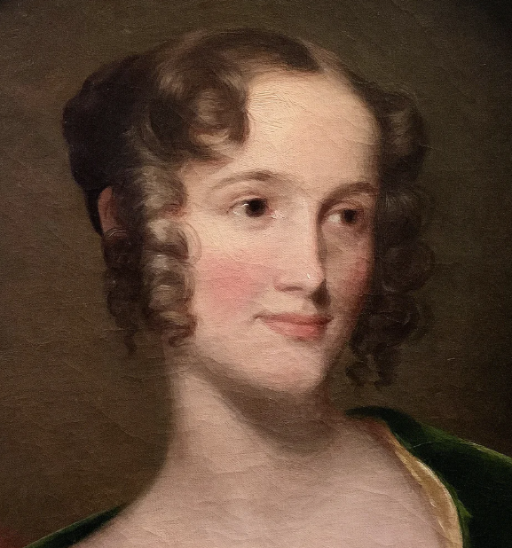
William Wadsworth married Emmeline Austin in early 1846.

Not long after their marriage, William began experiencing serious health problems.
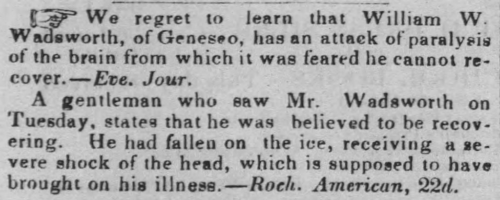

Although William Wolcott Wadsworth appeared to have recovered from his physical injuries, the newspaper account suggests that he continued to suffer from internal injuries.
Death of William Wolcott Wadsworth
William Wadsworth died on July 21, 1852, at the age of 42, leaving behind his widow and three young children: William Austin, Livingston, and Herbert.

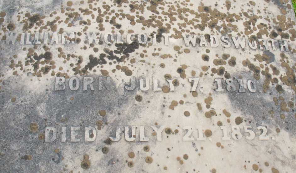
After his death, William’s brother James temporarily assumed responsibility for managing his affairs, including his extensive Ohio holdings.
Responsibility then passed to his widow, Emmeline. The Supreme Court of the State of New York advised her to sell her husband’s Lucas County lands, noting that they “bring in no income.”
1854

Another document from 1854 provides more description of Fountain Hill and the surrounding area. Titled “Field Notes of Fountain Hill,” the document records a surveyor’s work along the boundaries of Wadsworth’s lands.
The timing of the survey is significant. William Wolcott Wadsworth had died in 1852, leaving his extensive Ohio holdings to his widow, Emmeline. The 1854 survey appears to have been undertaken as part of an effort to document and assess the holdings, likely in preparation for their eventual sale. “Wadsworth Lands” began appearing for sale in 1855.
During this survey the surveyor encountered evidence of the earlier agricultural operation in the northwest part of Section 23.
The Old Farm in Section 23
As the surveyor followed the west line of the northwest quarter of Section 23, he encountered a spring stream writing, “crossed spring brook by old house where Benjamin Joy lived.”
He also recorded “improvements” along the line, such as the Eli Hubbard property across the Maumee Road in section 22, and identified places where improved land ended.
Clearly the agricultural center, or farm, that had existed in section 23 had ceased operations by 1854 being recognized only as the “old farm” or the “old place” in the field notes.
A Varied Landscape
The field notes also provide a detailed picture of the landscape seventeen years after the 1837 report. The surveyor repeatedly encountered an alternation between dry and wet country: dry oak openings, scrubby oak ridges, thick oak brush, sandy soil, wet poplar and alder swales, standing water, duck ponds, marshy prairie, wet grassland, and dry ridges.
In one portion of the survey, he described moving from an oak ridge into a great wet swale and then back onto another ridge, with the pattern continuing across the landscape. Elsewhere, he recorded a “great wet prairie.”
The Ottawa Flats
The character of the land changed again near the Ottawa River. Along the north line of Section 23 (Sylvania Avenue), the surveyor descended toward the Ottawa flats, where he encountered what he considered first-quality soil and excellent timber, including white oak, black walnut, ash, and basswood.
The river-bottom land was fertile and alluvial, distinctly different from the sandy uplands and oak ridges farther away. The surveyor crossed the winding Ottawa River several times as he followed the property boundaries, particularly making his way toward present day Central Avenue.
Roads, Railroad, and Improvements
By 1854, the landscape was also far more connected than it had been when Wampler surveyed the area in 1820. The field notes reference the Maumee Road, wagon roads, the railroad, established fences, cultivated improvements, houses, and bridges. Names mentioned during his travels are Hasty, Miner and Corey who owned lands bordering Wadsworth sections.
In Section 24, the surveyor recorded a road laid out along the southern section line (Central Avenue) and a bridge constructed over the Ottawa that was never opened and was eventually abandoned.
1855 – 1871
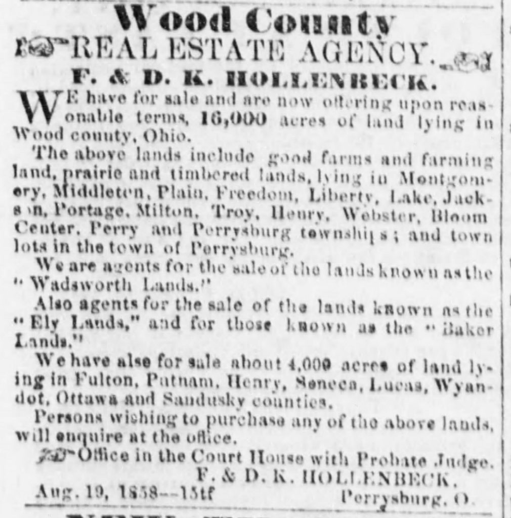
In March 1855, a local newspaper published a “Petition to Sell Land,” marking the beginning of the process of selling the Wadsworth lands.


A map from 1861 shows that Emmeline Wadsworth still owned a substantial amount of land. Her holdings appear under several variations of her name: her full first and last name, her first initial and last name, and her first and middle initials followed by her last name.

The selling off of Wadsworth lands continued for years.




The End of Fountain Hill
The sale of the Wadsworth lands appears to have largely ceased by 1875 with Josiah Albon being one the last purchasers in 1874.
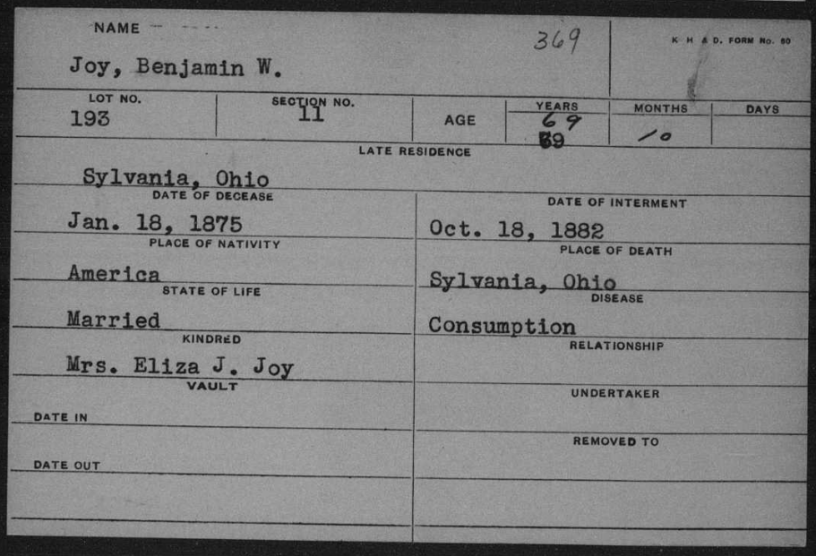
Benjamin Joy never left Sylvania Township. He died there on January 18, 1875 at the age of 69. He was buried in Joy Cemetery on Hasty Road in what is now Ottawa Hills. His remains appear to have been moved by his daughter Eliza to Woodlawn Cemetery in 1882.

Emmeline Wadsworth died in 1885.

By 1888, the Wadsworth lands, including Fountain Hill, had been sold and divided among several owners, much of the property having been converted to agricultural use and family farms. Some names remained associated with the land for decades, while other parcels continued to change hands. The purchase by Robert Stranahan in 1935 of a substantial tract that would later become Wildwood Preserve Metropark ultimately helped preserve a portion, albeit modified and modernized, of one of the varied natural landscapes that had once characterized the area around the Corners.
The Realization Is the Lesson
The history of the Corners, and the land that surrounded it, is among other things, the story of a landscape in transition. An Indigenous and natural landscape was gradually transformed as wagon roads extended through the former Oak Openings, farms and cultivated fields replaced portions of the open prairie and savanna, and wet ground was drained and cleared. The scattered groves and mature trees that had characterized the original landscape increasingly became small, isolated remnants within a vast, fenced-in, privately owned agricultural countryside, and eventually disappeared.
Research suggests that various separated areas, mostly Metroparks around northwest Ohio, preserve to varying degrees pieces of the mosaic that once covered the area surrounding the Corners. But no single area represents the landscape that once existed there.
Yes, landscapes change. But there is something to be said for the intrinsic value of preserving enough of the natural past, as a whole and as it existed, to maintain our ability to connect with and feel rooted in something that transcends our own time.
The historical record of the landscape around the Corners is only slightly better preserved than the native landscape itself. Much of that record was created by individuals and institutions with little interest in preserving the landscape, but considerable interest in surveying, dividing, settling, and transforming it.
For generations, the story of this landscape has largely been told through the difficulties it presented: swamps, mosquitoes, mud, dense dark forests, and the wildness that stood in the way of settlement. Those hardships were real, but they are not the whole story. They describe what the landscape made difficult for people who wanted to change it; they tell us considerably less about what was lost when that landscape was changed.
Today, we can reconstruct portions of that natural world through maps, surveys, land records, and historical accounts. But reconstruction is not preservation, and the record itself was shaped by an antipathy toward the natural setting it documented.
I can never experience the landscape that existed here in 1820 exactly as the people who lived and traveled across it did back then. But the records left behind allow us to eventually reconstruct and imagine some of what once existed before the Corners became what they are today, and perhaps seek out what might remain.~